KATHMANDU, Sept 22: On July 8, a predawn flash flood in Rasuwagadhi, a key border point between Nepal and China, caused massive loss of lives and property. The flood swept away the Nepal-China Friendship Bridge (Miteri Bridge), a customs yard, four hydropower projects with a combined capacity of 260 MW, and 24 containers loaded with electric vehicles and other goods. Insurance claims for the damages have already exceeded Rs 985.98 billion.
Rescue teams deployed by Nepal’s security agencies confirmed the death of nine people. Two police personnel and 17 civilians—11 Nepalis and six Chinese nationals—are still missing in Nepal’s territory. Home Minister Ramesh Lekhak further confirmed that 11 more people were swept away on the Chinese side, from where the flood originated. Search and rescue operations are ongoing, but authorities admit that hopes of finding survivors are fading.
Four rural municipalities in Rasuwa district—Gosaikunda, Amachhodingmo, Uttargaya, and Kalika—were the worst affected. The flood entered Nepal through Gosaikunda-2, but according to ward chairperson Kami Tshiring Tamang, no locals were harmed. “All those affected were outsiders—traders, workers, and security personnel,” he said.
Rasuwa Flood: ‘Not by Rainfall’
At first, it was widely believed that incessant rainfall caused the Rasuwa flood. However, climate scientists, after analyzing visuals circulating on social media, hesitated to attribute the disaster to rainfall alone. Nepal’s Department of Hydrology and Meteorology (DHM), the government body responsible for hydrometeorological data, also supported this skepticism. It has now confirmed that the disaster was triggered by supraglacial lake outbursts in Tibet, which caused devastation on both the Chinese and Nepali sides.
According to DHM’s Flood Forecast Section Chief Binod Parajuli, the Bhote Koshi flood was not caused by heavy rainfall. “Weather stations in both countries recorded only light rainfall,” he said.
Satellite data analyzed by the International Centre for Integrated Mountain Development (ICIMOD) and Nepal’s National Disaster Risk Reduction and Management Authority (NDRRMA) confirmed that extreme rainfall was not the cause.
Nitesh Khadka, a researcher studying Glacial Lake Outburst Floods (GLOFs) affecting Sino-Nepal transportation corridors, said the July 8 flood was caused by the drainage of supraglacial ponds and erosion of debris. Supporting his claim with satellite images, he noted, “Supraglacial lakes are dynamic and transient in nature.”
Khadka explained that supraglacial lakes form on the surface of debris-covered Himalayan glaciers. “They are small, temporary, and have varying dam compositions, making risk assessment difficult,” he said. His team has identified 400 such lakes in Sino-Nepal corridors including Kodari, Kerung, Kimathanka, and Hilsa, with Kerung alone hosting 96.
World’s most beautiful lakes

He added that Nepal’s Himalayas currently host more than 2,000 glacial lakes. “Our study shows their area has expanded by 25 percent in the last three decades,” he said.
Barely two months earlier, on May 15, a GLOF struck Limi in Humla district. On August 16, 2024, another GLOF hit Thame, a famous Sherpa village, echoing a similar disaster that occurred there in 1985.
All Sino-Nepal Transportation Corridors are Prone to GLOFs
GLOFs triggered by rising temperatures pose a growing threat to Nepal’s fragile connectivity with China.
 Like the Kerung-Rasuwagadhi route, all major border crossings with China are vulnerable to such hazards. A joint research article published in Science of the Total Environment on October 20, 2024, titled Glacial Lake Outburst Floods Threaten China-Nepal Connectivity, warned of the risks. Based on six key parameters, it found that 144 of 545 glacial lakes in Sino-Nepal corridors have a high level of GLOF susceptibility.
Nepali researchers Nitesh Khadka, Manish Raj Gouli, Bhaskar Shrestha, and Shankar Sharma, along with Chinese scientists Xiaoqing Chen, Weiming Liu, and Chonglei Zhang, jointly authored the paper. They identified Rasuwa, particularly the Kerung-Kathmandu corridor, as highly vulnerable.
Other prone regions include Kimathanka in Sankhuwasabha, Kodari in Sindhupalchowk, and Hilsa in Humla. The 2022 research showed Kerung hosts 265 glacial lakes, Kimathanka 1,257, Kodari 294, and Hilsa 765 across the border region.
Cross-Border Data Sharing on Floods
Chief District Officer of Rasuwa Arjun Poudel said some cross-border information-sharing mechanisms exist. “We keep receiving updates from our Chinese counterparts on rainfall and flood conditions, which helps us prepare,” he said. “But the July 8 GLOF went unnoticed on their side, which is why they couldn’t warn us in advance.”
Despite repeated calls from experts for early warning systems, no such institutional arrangement exists between Nepal and China. NDRRMA Chief Executive Dinesh Prasad Bhatta said China failed to alert Nepal in time. “We need an institutional and written mechanism for information sharing, not one based on personal contacts,” he said.
Road Corridors Along Rivers: A Challenge
Most of Nepal’s connectivity with China follows river corridors, making them highly vulnerable. In the east, the Tamor corridor runs along the Tamor River, while Kimathanka roads pass via the Arun River. The recently inaugurated Chuwakhola Bailey bridge in Humla links to the Karnali corridor, which also runs along a riverbank. Similarly, Kerung lies on the Trishuli River and Tatopani on the Bhote Koshi.
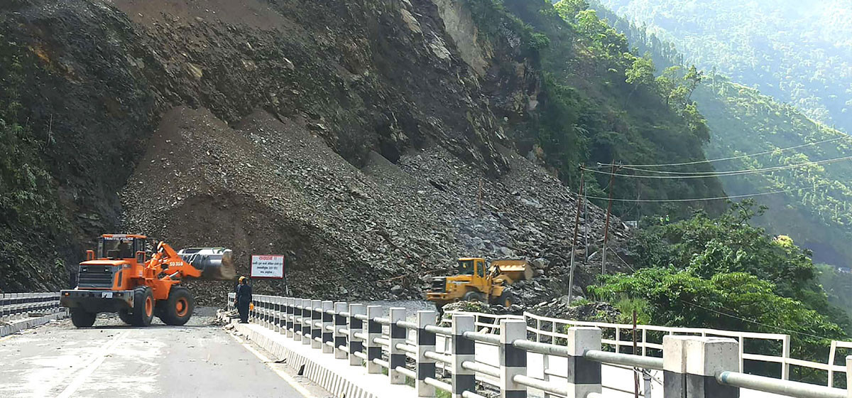
“Not all open spaces are appropriate for construction,” warned Khadka, criticizing the placement of critical infrastructure such as customs yards along riverbanks. For example, the July 8 flood heavily damaged the Timure customs point, which had been built with a budget of Rs 2.08 billion.
GLOFs: Not New to Nepal
According to ICIMOD, Nepal’s history with GLOFs dates back more than 450 years, with one recorded in the Seti Khola near Pokhara. However, transboundary road disruptions began in 1981, when a GLOF severely damaged Nepal-China roads.
The 2016 Bhote Koshi flood, triggered by a glacial lake outburst in Tibet, also swept away riverside homes and sections of the Araniko Highway. China had not informed Nepal in advance.
In 2019, scientists mapped 47 dangerous glacial lakes in the Himalayan region—21 in Nepal, 25 in Tibet, and one in India. With climate change accelerating, scientists warn that new glacial lakes are forming and existing ones are expanding faster than expected.
Nepal’s Efforts to Minimize GLOF Threats
Nepal has already lowered water levels at three glacial lakes—Tsho Rolpa, Imja, and another—and is preparing to mitigate risks at four more. No similar public reports exist from China, leaving risks high on both sides of the border.
Experts recommend lowering lake levels, establishing early warning systems, and adopting land-use planning. They also stress the importance of a Sino-Nepal diplomatic agreement to strengthen cross-border disaster management, supported by joint research, bilateral cooperation, and real-time data sharing.
Minimizing GLOF Threats
Nepal’s reliance on China for trade and transit has increased, especially after repeated blockades from India. Following a Transit and Transport Agreement (TTA) signed in 2016, China offered Nepal access to four seaports and in 2024 agreed to open 14 traditional border points.
Yet, the connectivity dream is increasingly threatened by climate change and GLOFs. Sino-Nepal road connectivity, first established with the Kodari Highway in the 1960s, remains fragile today.
“Nepal lacks technical capacity, but China can support us with real-time satellite observations and monitoring systems,” said Dr. Sudeep Thakuri, Associate Professor at Tribhuvan University.
 This article has been prepared with the support of the Internews Earth Journalism Network and the Nepal Forum of Environmental Journalists.