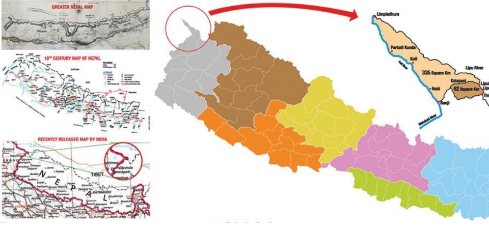
KATHMANDU, Aug 22: The three villages—Gunji, Nabi, and Kuti—shown on Nepal’s triangular map were under the administration of the Government of Nepal until 2035 B.S. Kalapani, Lipulekh, and Limpiyadhura are also included within Nepal’s official triangular map. Located below Limpiyadhura, the residents of Gunji, Nabhi, and Kuti were recorded as paying land taxes to the Government of Nepal until 2035 B.S.
Documents and receipts show that residents of these villages, included in the updated 2077 B.S. map, had been paying land taxes to Nepali authorities until 2035 B.S. Government records show that in 2035 B.S., Ratan Budha (Tinker), Panchyaura Budha (Budi), Mohan Singh Budha (Gabryang), Hari Singh Budha (Gunji), and Hari Krishna Budha (Nabhi) submitted their tax payments.
Moreover, the cadastral details of lands owned by Gunji, Nabhi, and Kuti villagers are still preserved in the Department of Survey (DoS). In 2038 B.S., when Dwarikanath Dhungel was the Chief District Officer of Darchula, he visited Gunji while returning from Kalapani. During his visit, villagers informed him that they held Nepali citizenship. “In 2038, while returning from Kalapani, I reached Gunji and spoke with some residents. They told me they had Nepali citizenship,” Dhungel recalled.
Residents of Nabhi, Gunji and Kuti used to pay land revenue to...

According to sources at the DoS, at that time, the land ownership details of the residents of Gunji, Nabhi, and Kuti were maintained in Form No. 7 of the Land Reform Office, which remains safely archived.
The Ministry of Land Management, Cooperatives, and Poverty Alleviation stated that before preparing the updated map, including Kalapani, Lipulekh, and Limpiyadhura, it collected more than a dozen pieces of evidence. Over 132 maps were gathered as part of the documentation, according to ministry officials.
The government also possesses directives issued by Prime Minister Chandra Shumsher Rana, which affirm that Kalapani, Lipulekh, and Limpiyadhura belong to Nepal. In one such directive resolving disputes between two villages in the area, Chandra Shumsher wrote: “Live together in harmony, pay taxes regularly, for both of you are my subjects.”
The primary basis for the government’s claim is the Treaty of Sugauli, signed on March 4, 1816. On behalf of Nepal, Rajguru Gajraj Mishra and Chandra Shekhar Upadhyaya signed the treaty, while Lieutenant Colonel Paris Bradshaw signed on behalf of the East India Company. The treaty defined the Kali River in the west and the Mechi River in the east as Nepal’s borders.
Nine months later, a supplementary treaty was signed, which the ministry considers a second proof. The original treaty had not included the plains stretching from Koshi in the east to Rapti in the west. The supplementary treaty, signed on December 8, 1816, returned these lands to Nepal after the Nepali side demanded them back. The British government sent a letter to this effect to the Government of Nepal on the same day. Based on this, Nepal’s western boundary was established up to Limpiyadhura, which remains Nepal’s strongest evidence.
Subsequently, another treaty was signed on November 1, 1860, between Nepal’s Prime Minister Jung Bahadur Rana and the British Government’s Lieutenant General George Ramsay. This treaty returned Banke, Bardiya, Kailali, and Kanchanpur to Nepal. Maps prepared at that time also indicated Nepal’s western boundary extending up to Limpiyadhura.
On January 7, 1875, the British prepared another map while demarcating Dang, which also showed Nepal’s western border up to Limpiyadhura. Nepal considers this another vital piece of evidence.
Similarly, Nepal has preserved additional proofs such as the 2015 B.S. voter list and the 2018 B.S. national census, both of which included Kalapani, Lipulekh, and Limpiyadhura within Nepal’s territory.