LAHAN, July 18: Gyanendra Ram from Bhorleni, Dhanagadhi Mai Municipality-13 in Siraha, has struggled for water for one and a half months. His deep bore well stopped yielding water, and his desperation grew.
The residents of this Chure foothill area used to rely on community wells. Every settlement had wells rich in water. Ram says, “Since uncontrolled exploitation of the Chure hills and protected area began, the water level has dropped rapidly. Many wells have already dried. Now even deep bore wells fail to produce water. If exploitation continues, the drinking‑water crisis here will become severe.” Around 150 households now trek to neighboring village wards just to quench their thirst.
Local officials in Dhanagadhi Mai Municipality consider uncontrolled deforestation and mineral extraction in the Chure and protected zones as the main cause of water shortages. Ram explains that arbitrary quarrying, logging in Chure to the north, uncontrolled riverbed mining, and rock blasting for stone mining have caused all settlement wells to dry up.
As wells run dry, residents from settlements like Mahuliya, Musahrnia, Mahuvadanda, Tenatol, Bhorleni, Khajanpuriya‑tol, Khutti, Madyan, Sarre suffer. Mahuliya residents have installed motor pumps on a neighbor’s well in Kasaha to meet water needs. But that source too has begun to fail, worsening the crisis.
“We installed motor pumps at the neighbor’s well in Kasaha to bring water,” says Bishwanath Yadav of Mahuliya, “Despite over two dozen motors, water levels have declined—now even that well is drying up.”
Sharmila Yadav of Mahuliya laments: “Without drinking water, how can we live? We suffer great hardship. Please halt the extraction activities that dry out our water sources.”
Mahuliya hosts about 60 households—55 of Yadavs, 2 Mahatos, 2 Rams, and 1 Sonar.
With main sources drying, water issues increasingly affect Nawtoli settlement of Ward‑7 in Ganeshman Charnath Municipality, Dhanusha. Residents there attribute their hardship to uncontrolled extraction in the Chure hills north of Charnath River and Kamala River. Kamal Mahato from Nawtoli shares: “Even running a tap for hours doesn’t fill a bucket.” The water department-built well in front of his house stopped producing water two years ago.
Severe water crisis in Chure area calls for urgent action

Pankaj Kumar Mishra of Ward‑12, Murali Pokhari Tol in Parsa says this year witnessed the worst water crisis he has ever seen in Birgunj. “The problem existed before,” he says, “but this year it peaked.”
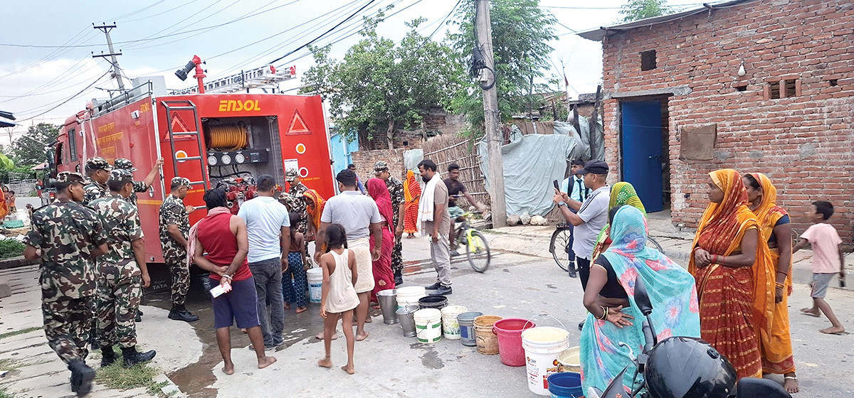
His family of 12 now faces daily hardship from water scarcity. They lack water even for cooking and bathing. In Birgunj, 28 of 32 wards have dried tube‑wells and other sources, leaving around 250,000 people affected.
According to the 2021 census, Birgunj had 272,000 residents, but now nearly 300,000 live there. Municipal engineer Rakesh Sah explains people draw water using motor‑powered tube‑wells. But in the dry season these fail, forcing residents into extreme distress. Authorities now distribute water via tankers, but Sah says this serves only as temporary relief. A lasting solution, he says, lies in pipelines delivering water directly to homes.
The crisis extends beyond Birgunj into rural areas. Most household tube‑wells have dried. Residents who expected easy water through tube‑wells now crowd at the Birgunj branch of the Water Supply Corporation. The crisis affects not only Birgunj but also other Madhesh districts like Siraha and Dhanusha. As rivers originating in Chure dry up, southern Madhesh communities also face severe drinking water shortages.
Some northern settlements endure up to four months of acute water shortage each year outside of monsoon. Even during the rainy season, they rely on murky river water.
Water Supply Minister Pradeep Yadav says the accelerated bore‑well installation in Birgunj to address the crisis. “But the long‑term fix must treat the root cause: Chure hill degradation. Without controlling deforestation and mining in Chure and protected areas, the water crisis in Madhesh will worsen.”
Chief Minister Satish Kumar Singh of Madhesh Province has spearheaded efforts to supply drinking water via eight water cannons (each with 5,000‑litre capacity) deployed in Birgunj. These cannons — managed by the province and operated by the Nepali Army — deliver around 40,000 litres per dispatch.
Earlier, the province had deployed three tankers from the Division Forest Office for water supply. The Nepali Army also provides seven tankers and a water cannon in affected areas.
Land titles only, no land
In the southern part of Madhesh Province, in Saptari district, the village Dighiya now exists only in name—this once fertile area has turned into a barren desert. The village has shifted eastward and now borders the next village, Chanhai. The reason: the shifting course of the Balan River, which eroded the village's land.
Once known as a landowner’s hub, Dighiya housed more than a thousand families and had dense settlements. Its fields once yielded ample rice and wheat. Now, the fields lie parched and lifeless, resembling a desert land.
To preserve the village, locals built an embankment. Pointing to it, Rajlal Yadav said, "Here we had a broad, deep pond. It was as high as this embankment. Now, sand has filled that place and turned it barren. This river has left us empty-handed."
Previously, water flowed from northwest to south, and people easily accessed streams for daily use. But in 2046 BS (1989–90 AD), the Balan River suddenly changed its course into the settlement and flooded it. The villagers relocated eastward, but the river kept cutting through. Five years later, the river submerged their new settlement again. With no land elsewhere, they shifted another two kilometers east toward Chanhai. Flooding a decade ago even affected that area. "We had no way to save our fields from Balan’s floods and shifting banks," locals lament, "Despite appealing to leaders and government, no preventive or control measures came, so each year the river steals our land."
Indradev Yadav, a longtime resident, recalls: "This place holds childhood memories. My parents farmed it and produced good harvests. Their farming even paid for our higher education. Now that greenery with our fields has disappeared."
Water from the Balan River irrigated nearly 500 bighas of fields in Dighiya, Chanhai, and Malhaniya. But as the river changed course, all fields turned barren. Farmer Rajlal Yadav said in a local dialect, “The very day the Balan river entered our fields, we lost everything. Now we wander from edge to edge.”
The river now threatens the village itself. Once only 20 feet wide two decades ago, today it has grown vastly wider. The river’s old course has split, creating multiple channels across the land. Over ten years, a new channel emerged east of the old course. Interestingly, no one in this village owned land in the neighboring villages, and vice versa. Kunta Yadav says: "Everyone here shared enough land; nobody sold land or bought it from outside. But now all the farmers face hardship together."
In Itaharwa Tol, Sakhuwanakarkatti, under Siraha’s municipality, Bihari Yadav had inherited seven bigha of land and was a landowner until ten years ago. Now he holds land documents for nearly ten bigha—but he has no land. Balan River swallowed his original parcel, changing his identity. Similarly, Hari Yadav’s family once owned some 22 bigha, but now they have none. The reason: the shifting course of the river.
Villages once famed for landowners—like Itaharwa, Bhagwanpur, and Tilebona—have seen their identity fade as Balan shifted west and drowned fertile land. These villages produced abundant crops and had dense settlements. A once-blessed river has turned into a curse, causing fear of food shortages. Previously thriving rice and wheat fields now lie overtaken by the river.
Experts attribute Balan river’s destructive behavior to unregulated exploitation of Chure hills, from where the river originates. Landowners in the region say the river altered its course due to deforestation and gravel mining in Chure. Dr Bijay Singh Danuwar, a watershed expert, adds, “Controlling damage to rivers from Chure-origin flows means stopping extractive practices in Chure. Unless exploitation ends, all efforts to control the river downstream will fail.”